In a rare and astonishing event, a colossal landslide in East Greenland’s Dickson Fjord triggered a mega-tsunami and a mysterious seismic signal felt across the globe—an alarming reminder of nature’s raw power fueled by climate change.
Arctic Seismic Pulse Baffles Scientists Worldwide
On September 16, 2023, seismic instruments around the world detected a peculiar, rhythmic pulse occurring every 92 seconds. This subtle but persistent vibration, dubbed an Arctic seismic heartbeat, lasted nine days and was strong enough to shake the Earth’s crust from Alaska to Australia—yet no typical earthquake could explain the anomaly.
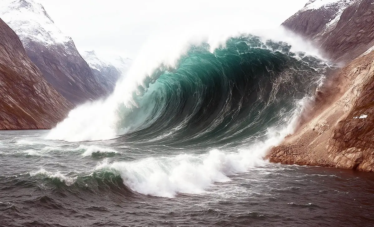
The origin? A hidden cataclysm in Greenland’s Dickson Fjord, where over 25 million cubic yards of rock and ice—the equivalent of 10,000 Olympic swimming pools—suddenly collapsed into the fjord, unleashing a 650-foot-high tsunami wave that ravaged research equipment and rocked the water like a giant piston.
Dickson Fjord Landslide Causes Historic Mega-Tsunami
New satellite imagery revealed a fresh scar on the mountain face, confirming the massive landslide. The wave surged through the narrow two-mile fjord, slammed into the headland, and rebounded, setting off a continuous sloshing motion, known as a seiche, that raised and lowered the water surface by up to 30 feet.
This rhythmic wave motion, caused by the Greenland tsunami 2023, created a seismic signature never seen before from a water-based event. While one team estimated an 8.5-foot amplitude, others placed it closer to 23–30 feet, depending on the fjord’s underwater shape.
Climate Change Behind Arctic’s Unseen Dangers
Experts link the incident to climate change, which has melted the glacial ice that once stabilized the slope. Without its icy support, the mountain gave way, much like what occurred during the deadly 2017 Karrat Fjord tsunami that killed four people.
“This is yet another example of how warming Arctic temperatures are reshaping the planet,” said Dr. Alice Gabriel of UC San Diego. “These unusual events are becoming more common and unpredictable.”
Next-Gen Satellites Unlock Arctic Mysteries
Thanks to the Surface Water and Ocean Topography (SWOT) satellite launched in 2022, researchers now have an unprecedented view of sea surface changes. Unlike older altimeters, SWOT scans a 30-mile-wide swath with 8-foot resolution, capturing real-time data from remote regions like Greenland.
“This is a major leap in Earth observation,” said Oxford University’s Thomas Monahan, emphasizing that such technology is crucial to detecting oceanic extremes, including tsunamis and storm surges.
Greenland’s Quiet Warning to the World
The Dickson Fjord landslide has sparked a wave of research, uniting over 70 scientists from 41 institutions. Their collaborative effort decoded this geological mystery using field data, supercomputers, and seismic modeling.
“This event proves that even the quietest parts of the planet can unleash global shockwaves,” said Robert Anthony of the U.S. Geological Survey. “We must listen more closely.”
Authorities are now evaluating early warning systems that integrate satellite imagery with seismic alerts, aiming to protect ships and Arctic communities from future climate-triggered disasters.
Read More: 10 Most Technologically Advanced Countries in the World


