Looking for accurate Lyari Expressway directions in Karachi? This 2025 guide provides complete details on the route map, entry and exit points, tolls, and important interchanges. Whether you’re commuting from Sohrab Goth to Mauripur Road, this guide helps you navigate the entire expressway efficiently.
What is the Lyari Expressway?
The Lyari Expressway is a key signal-free corridor that runs along the Lyari River, connecting the northern and southern zones of Karachi. It reduces congestion on city roads and provides direct access to major intercity routes.
- Length: 38 kilometers
- Lanes: 4-lane dual carriageway (2 lanes each side)
- Speed Limit: Up to 80 km/h
- Toll Points: Installed at each entry and exit
- Vehicle Restriction: Heavy vehicles and motorcycles are not allowed
READ MORE: Sindh Approves 1,000 Electric Buses for Karachi
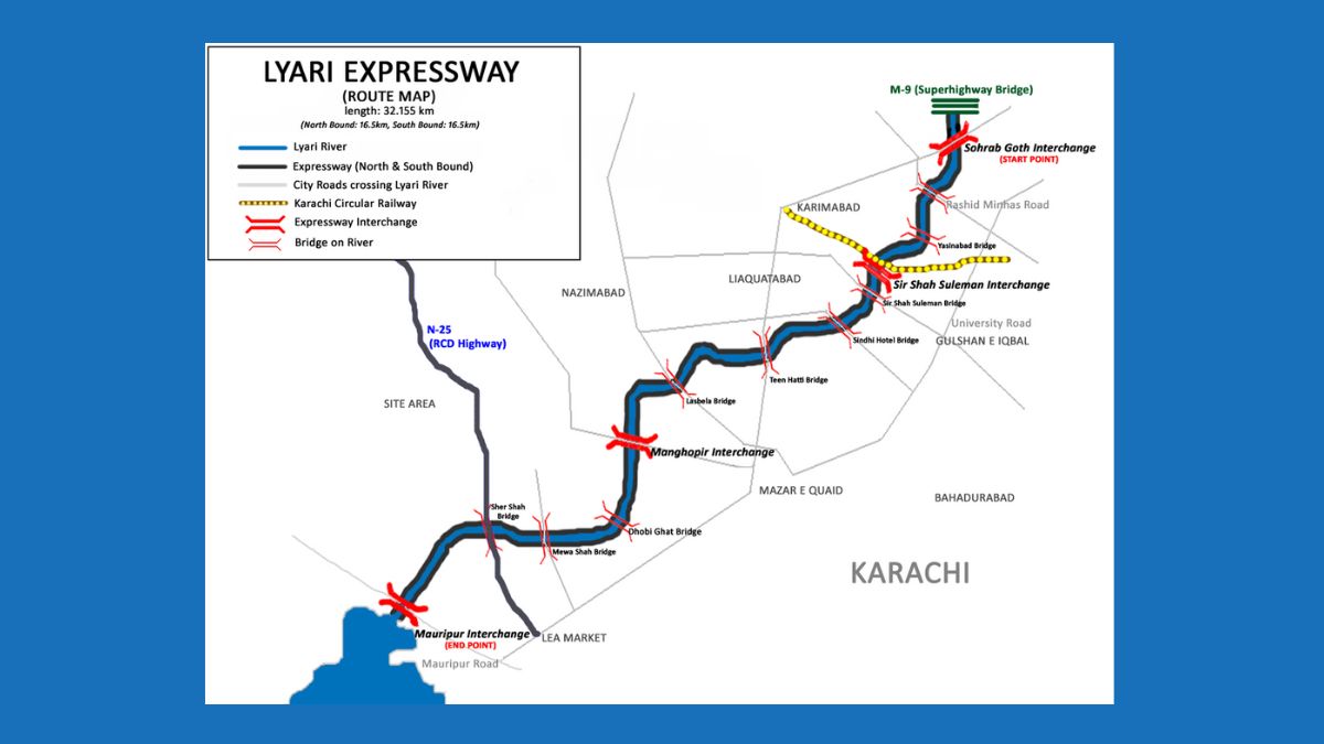
Lyari Expressway Route Map and Interchanges
Understanding the Lyari Expressway directions becomes easier with knowledge of its key interchanges:
1. Sohrab Goth Interchange (Start Point)
- Connects with M9 Motorway and Shahrah-e-Pakistan
- Ideal for traffic entering from Hyderabad or Northern Karachi
2. Sir Shah Suleman Interchange
- Located near Liaquatabad, Gulshan-e-Iqbal, and National Stadium
- Provides access to central urban neighborhoods
3. Manghopir Road U-Turn
- Midway point offering a U-turn ramp
- Access point for Nazimabad, Saddar, and surrounding areas
4. Mauripur Road Interchange (End Point)
- Connects with Kemari, Gulbai, Hawke’s Bay, and Coastal Areas
- Final exit for southern Karachi-bound traffic
Infrastructure and Features
- Signal-Free Travel: Designed for uninterrupted movement
- Strategic U-Turns: Help drivers correct missed exits
- Toll Collection: Applied per entry/exit to regulate flow
- Urban Green Zones: Includes park areas like Ama Kulsoom Baloch Park
History and Project Development
- Launch Year: 2002
- First Phase Opened: February 2008 (southbound)
- Project Completed: January 2018 (northbound)
- Cost Increase: From Rs. 5.09 billion to Rs. 12.99 billion
The project was delayed due to land acquisition and funding challenges. Despite setbacks, the Lyari Expressway is now fully operational and serving thousands of commuters daily.
Displacement and Resettlement
Due to its construction:
- Over 24,000 families were displaced
- Approximately 15,000 structures were removed
- Resettlement carried out in areas like Taiser Town and Baldia Town
Government compensation and new housing developments helped reduce the long-term impact on displaced families.
READ MORE: Karachi Bus Routes 2025 – Complete Guide to Public Transport, Fares & Timings
Travel Tips for Using Lyari Expressway
| Tip | Details |
|---|---|
| Navigation Tools | Use GPS to avoid missed exits |
| Follow Speed Limits | Maximum speed allowed is 80 km/h |
| Toll Payment | Keep cash or RFID cards ready |
| Entry Restrictions | No motorcycles or heavy trucks allowed |
Final Thoughts
The Lyari Expressway directions guide is essential for anyone traveling across Karachi. It ensures faster, safer, and more organized travel between the city’s north and south ends. With accurate knowledge of entry and exit points, you can avoid traffic and reach your destination on time. Stay Updated With Bloom Pakistan


